
LONG ISLAND GLACIAL GEOLOGY at Montauk Point
FIELD TRIP STOP – TERMINAL MORAINE AND OUTWASH NEAR THE EAST END OF LONG ISLAND
LOCATION: Enter Montauk Point State Park at the very east end of Long Island’s south fork. Park in lot across the street from the park restaurant. Take the dirt path down to the shoreline. The historic Montauk Lighthouse will be to your right (south) in the distance. Continue to walk along the shore towards the lighthouse and then further southwest. Around the base of the cliff made up of glacial sediments adjacent to the lighthouse will be many huge boulders placed there to deflect wave energy and reduce erosion. Once past this you will enter a swale of sand and cobbles before reaching a second prominent cliff of glacial material. Other exposures of glacial sediment are found along the southern shore further west.
GEOLOGIC FEATURES: Glacial Till of the Ronkonkoma Terminal Moraine; Outwash Plane (Stratified Drift) sediments; Erosion and erosion prevention measures.
DESCRIPTION: During the last glacial advance of the Pleistocene (Wisconsin Stage), the ice reached the southern part of Long Island (20,000 ya) carrying huge amounts of rock debris from the north. This sediment was eventually deposited as Till, a mixture of unsorted, unstratified sediment ranging in size from clay to huge boulders. Rocks are commonly metamorphic as well as igneous and sedimentary rocks. This accumulation of Till formed a Terminal Moraine. This moraine was formed as materials within the glacier’s melting edge was dropped in place as the glacier advanced at the same rate as it melted back. The southernmost moraine is called The Ronkonkoma Moraine. A second and slightly younger moraine (Harbor Hill Moraine) formed in a similar manner and is exposed along the north shore and fork of Long Island. Flowing south of a terminal moraine, streams carrying finer gravel, sand, and silt are deposited as stratified beds of sorted sediments forming an Outwash Plain. Subsequent erosion has rapidly eroded the unconsolidated glacial sediment of eastern Long Island leaving steep cliff faces the are gradually receding over time due to wave action. Attempts at erosion prevention have had varied success.
STUDENT QUESTIONS:
(1) When a glacier recedes, does it actually stop moving forward? Explain.
(2) Describe the analogy of the formation of a Terminal Moraine with the actions of a conveyer belt.
(3) Describe the events of glacial advance and recession involved in the formation of both the Ronkonkoma and Harbor Hill moraines.
(4) What are two attempts that have been made to halt or reduce the amount of erosion at Long Islands east end?
(5) Describe the geoloic events that have taken place to account for the outcropping of Stratified Drift (Outwash) above the Till.
(6) CHALLENGE: What is (are) the underlying reason(s) for the glacial-interglacial cycles of the Pleistocene Epoch
(7) CHALLENGE: What is the average time between successive glacial maximums of the Pleistocene.
SELECTED REFERENCES:
-Schuberth, Christopher J. 1968, The Geology of New York City and Environs. The Natural History Press, Garden City, New York. 304 pp.
PHOTOS:
The photos below will lead you along a shoreline path from north of the Montauk Lighthouse, around its base, and then to more exposures of glacial deposits several hundred feet southwest of the lighthouse.
%20(Large)_JPG.jpg)
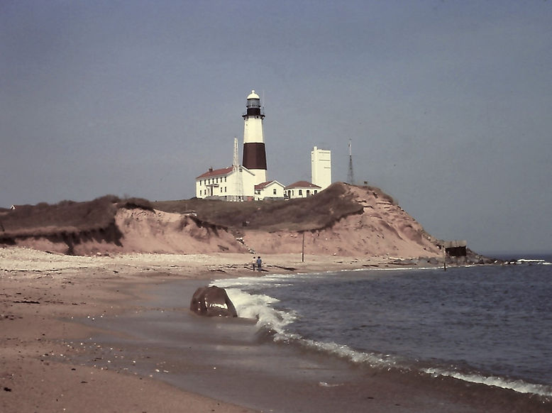
Figure 1 - Looking south towards the Montauk Lighthouse shortly after descending the hill from the parking area. Large boulders have been eroded from the nearby glacial deposits. (Photo 2017)
%20(Large)_JPG.jpg)
Figure 2 - Large boulders were artificially moved to the base of the cliff supporting the lighthouse in order to form a breakwater slowing the rapid landward erosion of the cliff. The relatively flat surface of the boulders near the wire fence can be used as a path. (Photo 2018)
%20(Large)_JPG.jpg)
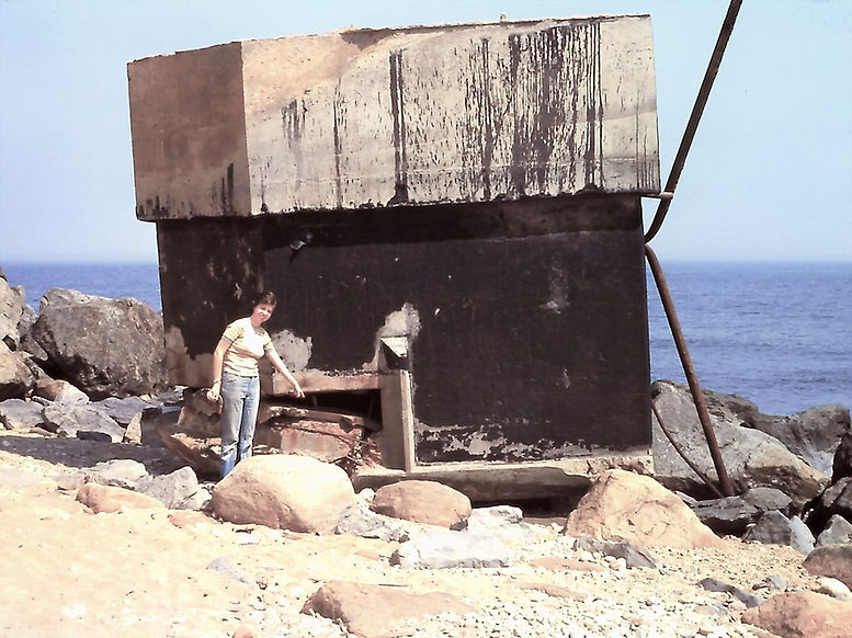
Figure 3 - Looking further to the suthwest, we see a second prominence of glacial sediment in the distance. In mid-photo is an upside down artillary bunker from WWII. As erosion threatened to undermine its position at the top of the cliff, the U.S.Coast Guard simply pushed it over the side of the cliff before it had a chance of harming the public. The opening in the bunker trough which weapons protruded was subsequently covered by steel plates for the sake of public safety. (Photo 2018)
%20(Large)_JPG.jpg)
Figure 4 - Further on down the path, The swale between the two prominences becomes visible. (Photo 2018)
%20(Large)_JPG.jpg)
Figure 5 - Notice the top of the second prominence of glacial material in the distance. The hummock is another defense bunker to the left along with concrete-walled rooms to the right presumably used by the military during WWII. This photo was taken in 2018. Note the distance between the edge of the distant bunker and the cliff. Compare that with the photo below taken in 1976.
COMPARE TH.E ABOVE PHOTO WITH THE ONE BELOW TO COMPARE CLIFF EROSION OVER TIME
%20(Large)_JPG.jpg)
Figure 6 - This photo, taken in 1976, over 40 years before that in the above photos, appears to show a wider area between the hummock and cliff edge. There are no preventative measures on this cliff to prevent arosion as have been taken on the cliff protecting the lighthouse.
COMPARE ABOVE PHOTO WITH THE ONE BELOW TO OBSERVE EMPLACEMENT OF THE BUNKER,
%20(Large)_JPG.jpg)
Figure 7 - This photo taken in 1974 from the same angle as the figure directly above (1976), is missing the bunker which had not yet been dislodged from its position atop the cliff.
%20(Large)_JPG.jpg)
Figure 8 - Close-up of WWII military bunker. See the opening to the bottom left through which weapons were protruded. This photo was taken in 1976 before the opening was sealed with metal plates.
%20(Large)_JPG.jpg)
Figure 9 - In the 1970's an erosion control project was undertaken to halt the erosion near the base of the cliff supporting the lighthouse. The above photo was taken in 1974.
%20(Large).jpg)
Figure 10 - The cliff below the lighthouse was terraced and boards was placed against the vertical wall of each step. It didn't take long for storms to tear away at the boards as seen in this 1976 photo.
%20(Large)_JPG.jpg)
Figure 11 - Photographed in 1976, this is another view of the unsuccessful attempt at erosion control,
%20(Large)_JPG.jpg)
Figure 12 - Photographed in 2017, over 40 years later than Figures 9 and 10, we see the remnants of the terracing project. The upper edge of the subsequently constructed artificial "boulder field" extending to the shoreline below can be seen here.
%20(Large)_JPG.jpg)
Figure 13 - As for Figure 11, note the early attempt of terracing and boards to control erosion. (Photo 2017)
%20(Large)_JPG.jpg)
Figure 14 - Erosion of Stratified Drift and Till just past the bunker in 1976
%20(Large)_JPG.jpg)
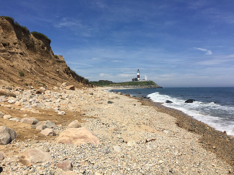
Figure 15 - Continuing to the southwest, we see the swale of sand and cobbles. (Photo 2017)
%20(Large)_JPG.jpg)
Figure 16 - Continuing to the southwest. The hummock is a WWII bunker and accompanying series of rooms. (Photo 2017)
%20(Large)_JPG.jpg)
Figure 17 - Just past the lighthouse on the path, but now looking to the northeast. (Photo 2017)
COMPARE FIGURES 18,19, AND 20 BELOW TAKEN IN 2012, 1981, AND 1976 RESPECTIVELY, NOTING
THE EMPLACEMENT OF THE BOULDER RIFRAF AND THE BUNKER OVER TIME.
%20(Large)_JPG.jpg)
Figure 18 - Photo taken in 2012 looking to the northeast. Note the bunker and extensive riprap used to prevent erosion. The Montauk Lighthouse was constructed in 1796. Approximately 200 ft of the cliff has disappeared since the lighthouse was built; hence, the efforts to halt erosion.
%20(Large)_JPG.jpg)
Figure 19 - Photo taken in 1981. Compare to Figure 18. Note the paucity of riprap boulders.
%20(Large).jpg)
Figure 20 - Photo taken in 1976. Compare to Figure 19 taken in 1981. Note the absence of the bunker. Also note the horizontal Glacial Lag deposit commonly found in places between the Till and the Stratified deposits of Montauk Point.
%20(Large)_JPG.jpg)
Figure 21 - Looking to the northeast from the base of the second prominence towards the Montauk Lighthouse. (Photo 2018)
%20(Large)_JPG.jpg)
Figure 22 - Taken further southwest from the previous photo. Glacial sediments composing the cliff are Till overlain by Stratified Drift (Outwash), (Photo 2018)
%20(Large)_JPG.jpg)
Figure 23 - Further southwest from Figure 22. (Photo 2018)
%20(Large)_JPG.jpg)
Figure 24 - Exposed along the southwestern prominence, here we see Glacial Till overlain bt Stratified Drift (Outwash Plain deposits laid down by streams flowing from melting glaciers. (Photo 1974)
%20(Large)_JPG.jpg)
Figure 25 - As for the figure above, Till overlain by Stratified Drift (Outwash). (Photo 1976)
%20(Large)_JPG.jpg)
Figure 26 - Looking to the southwest from the second prominence. (Photo 1974)