
YELLOWSTONE NATIONAL PARK
FIELD TRIP STOP – HOT SPOT CONTROLLED VOLCANISM WITHIN AND NEAR A COLLAPSED CALDERA.
LOCATION: Yellowstone N.P. is located in the northwest corner of Wyoming and the bordering parts of northeastern Idaho and southwestern Montana. On this field trip we will enter Yellowstone from the north and then travel counterclockwise along a larrge loop within the park. First we will visit Mammoth Hot Springs. Continuing south, we pass Obsidian Cliff before reaching the Norris Geyser Basin. Continuing south along western part of the loop we enter the Upper Geyser Basin containing Old Faithful, Chromatic Pool, Grand Geyser, and Castle Geyser. Moving counterclockwise to the eastern part of the loop we encounter Yellowstone Lake, the Mud Volcanoes, and the Lower Falls of Yellowstone Canyon along the lower half of the loop. Continuing north we pass the Basalt Flows of Canyon Narrows and then Tower Fall before again reaching Mammoth Hot Springs.
GEOLOGIC FEATURES: Obsidian; Columnar Jointing; Rhyolite-Andesite-Basalt Lava; Tuff; Geyser; Hot Spring; Mud Volcano; Fumarole.
DESCRIPTION: The oldest rocks in Yellowstone National Park are PreCambrian Metamorphics in the northernmost part of the park. Paleozoic and Mesozoic rocks are found in the far northern and southern parts of the park. The next older rocks are Tertiary (Eocene) Andesitic Pyroclastics and flows and Basalt flows of the Absaroka Range.
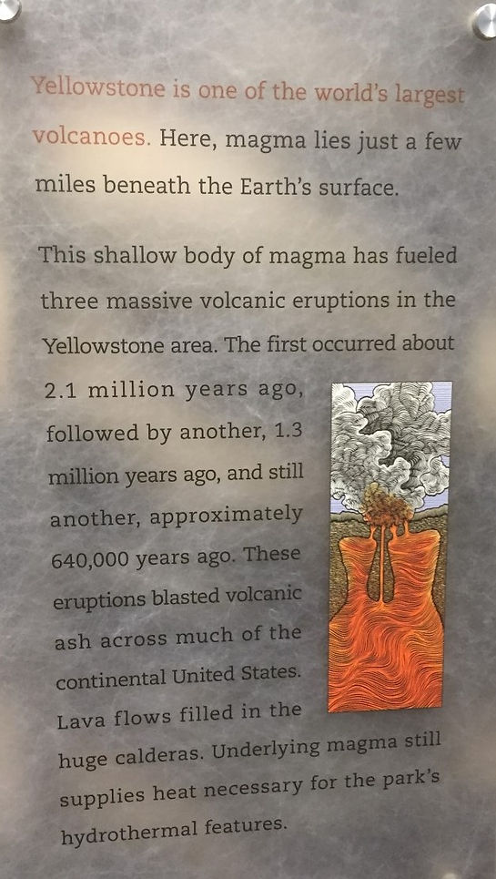
During the Quaternary (Pleistocene) three major volcanic episodes culminated about 600,000 years ago as Rhyolitic magma, high in silica, moved towards the surface eventually creating a Super-eruption. Cubic miles of material were ejected. Collapse of the volcanic roof resulted in a huge caldera approximately 25 x 40 miles in size. Subsequent to the eruption the caldera was filled with Rhyolitic Lava, minor basalt flows, and Welded Tuffs. These Tertiary and Quaternary Period rocks cover most of the park.
Today, the geologic phenomena associated with the park, such as hot springs, geysers, fumaroles, and mud volcanoes, are the result of the proximity of magma to the surface resulting in the heating of ground waters and their rise to the surface.
STUDENT QUESTIONS:
(1) Which type of lava is richer in silica, Rhyolite or Basalt? What role does the amount of silica have in whether a volcanic eruption is violent or quiescent?
(2) What controls whether or not silica or calcium carbonate is deposited from Hot Springs?
(3) How does a Geyser differ from a Hot Spring?
(4) What is a Tuff? How are the particles that form a Tuff formed?
(5) What are the dates of the last three major Super-eruptions at Yellowstone? Do they appear to occur on a regular basis?
(6) CHALLENGE – Given the movement of the continent over the Hot Spot, what will eventually happen to the hydrothermal activity in Yellowstone? Explain.
(7) CHALLENGE – What circumstances govern the degree to which a geyser eruption will occur on a regular (time interval) basis?
(8) CHALLENGE – What might be the physical worldwide effects of an upcoming Supervolcanic Eruption?
SELECTED REFERENCES:
-Harris, A. and E. Tuttle. 1983 (3rd ed.). Geology of the National Parks. Kendall/Hunt Publishing Company. Dubuque, IO. 554 pp.
-Harris, D.V. and E.P. Kiver. 1985 (4th ed.). The Geologic Story of the National Parks and Monuments, John Wiley and Sons, New York, 464 pp.
-National Park Service. Yellowstone National Park - Geology. Accessed on Jan. 24, 2020:
https://www.nps.gov/yell/learn/nature/geology.htm
PHOTOS: (Dates of photos are included)
_JPG.jpg)
Figure 1 - (2016) - Mammoth Hot Springs. These Springs are composed of the mineral Travertine. This mineral, a form of limestone (CaCO3), is the result of dissolution of calcareous rock buried below the surface.
_JPG.jpg)
Figure 2 - (2016) - Mammoth Hot Springs. Although these Springs lies outide the boundary of the caldera, the water is heated below by the same magma system responsible for heating waters elsewhere in the park.
_JPG.jpg)
Figure 3 - (1973) - Mammoth Hot Springs. This photo was taken 43 years earlier than the Figures above. Shifts in the vents supplying water to the Hot Springs has caused changes in the shape of the travertine deposits. Since the supply of water is primarily diirected by a subsurface fault, any one of the many earthquakes in Yellowstone can potentially "change the plumbing" of the hydrothermal system.
_JPG.jpg)
Figure 4 - (1973) - Mammoth Hot Springs. Variation in the color are caused by the presence of algae adapting to the varying temperatures of water.
_JPG.jpg)
Figure 5 - (1975) - Mammoth Hot Springs as it appeared in 1975
_JPG.jpg)
Figure 6 - (1973) - Obsidian Cliffs - These cliffs are formed of Quaternary Rhyolite flows containing pieces of Obsidian - a volcanic glass. Obsidian forms when ejected lava cools so quickly that crystallization into component minerals cannot take place. Pieces of differentially weathered Obsidian are found at the base of the cliff. Remember, though, that pieces of rock may not be removed from any National Park or State Park.
_JPG.jpg)
Figure 7 - (1973) - Basaltic Lava flow seen on the way from Mamoth Hot Springs to Norris Geyser Basin. Note the characteristic vertical Columnar Jointing due to shrinking upon cooling.
_JPG.jpg)
Figure 8 - (1973) - Norris Geyser Basin - This Basin resides above the northern edge of the Caldera. It contains the hottest waters in the park and are particularly acidic. . Trails composed of boardwalks and bare ground wind through the basin. Visitors get to experience the distinctive odor of sulfur, the presence of which can be observed by the yellow-brown staining near Fumaroles.
**VIDEO LINK: Norris Geyser Basin - https://youtu.be/kU5bonqb4Pw
_JPG.jpg)
Figure 9 - (2016) - Waters are controlled by a subsurface intersection of two faults.One of these faults experienced a major earthquake (about 7.4 in Richter magnitude) in 1959 illustrating the potential of subsurface faulting to direct future hydrothermal activity. In the above photo we see a Fumerole as well as scattered Chromatic Pools whose colors are reflective of Thermofiles adapting to different water temperatures..
_JPG.jpg)
Figure 10 - (2016) - A hot spring runoff channel. Colors are the result of algae, bacteria, and other microbes interacting with varying water properties.
_JPG.jpg)
Figure 11 - (1973) - Grand Geyser is found in the Upper Geyser Basin. It has been called the tallest, predictable geyser in the world, reaching heights of 150-200 feet and erupting every 7-15 hours.
_JPG.jpg)
Figure 12 - (1975) - Castle Geyser is also located in the Upper Geyser Basin and so named for its shape caused by the buildup of siliceous particles (sinter) forming a rock called Geyserite. Waters erupting from the geyser are particulary rich in silica provided by buried Rhyolite lava flows that dominate the surroundings.
_JPG.jpg)
Figure 13 - (1973) - Chromatic Pool in the Upper Geyser Basin. Water temperatures, hotter in the center getting gradually cooler towards the margins, control the appearance or colorful thermophiles.
_JPG.jpg)
Figure 14 - (1975) - Chromatic Pool in the Upper Geyser Basin. The central part of the pool lacks thermophiles and so its clear bluish color reflects the simple scattering of blue light in water. Towards the perimeter of the pool, colors change to reflect the presence of differing thermophile microorganisms each adapted to the progressively cooler temperatures away from the pool's center
.png)
Figure 15 - (2016) - Old Faithful geyser is found in the Upper Geyser Basin and is named as such due to its faithful adherence to a regularly scheduled eruption that averages close to 65 minutes. Fountain heights usually approximate 100-150 feet. The Upper Geyser Basin contains the highest concentration of geysers and hot springs in the world.
_JPG.jpg)
Figure 16 - (1973) - Mud Volcano (Mud Pots) are found in the eastern part of the loop as you head counterclockwise from the Upper Geyser Basin. These are hot springs that contain boiling mud that is not flushed out of the system due to diminished water flow.
_JPG.jpg)
Figure 17 - (1975) - The Lower Falls. Here the Yellowstone River plunges 308 ft. The canyon walls cut through the thick Quaternary Rhyolite Flows and Tuffs that filled the ancient caldera formed by the supereruption that occurred just over 600,000 years ago.
_JPG.jpg)
Figure 18 - (2016) - A closer view of the Lower Falls of the Yellowstone. It is commonly thought that the Falls flow over more resistant rhyolite than the rocks downstream within the canyon which were differentially weakened by hydrothermal activity.
_JPG.jpg)
Figure 19 - (1973) - Tower Fall - Further north of the Lower Falls of the Yellowstone, near the upper part of the eastern loop, is Tower Fall. Its drop is 132 ft. It is named for the pinnacles at the top of the Fall. These pinnacles are a result of the erosion of a columnar basalt flow which had cracks between tall hexagonal columns (due to shrinking during cooling). Tower Creek then drops precipitously over more easily eroded Tertiary (Eocene) volcanic gravels to form Tower Fall.
_JPG.jpg)
Figure 20 - (2016) - Within the Old Faithful Visitor Center is an illustration of volcanic events over the past 15 million years resulting from the movement of the North American Continent over a Hot Spot.
_JPG.jpg)
Figure 21 - (2016) - Within the Old Faithful Visitor Center is an illustration of the formation of the stationary Hot Spot currently under Yellowstone.