
BRYCE CANYON N.P.
FIELD TRIP STOP – JOINT-CONTROLLED WEATHERING OF TERTIARY ROCKS TO PRODUCE UNIQUE PINNACLES (HOODOOS).
LOCATION: About 80 miles by road east of Cedar City, Utah.
GEOLOGIC FEATURES: Law of Original Horizontality; Differential Erosion; Weathering; Erosion; Oxidation of iron-bearing sediments; Jointing; Pinnacles (Hoodoos, Towers, Needles, Spires, Pillars, Columns): Physical Weathering; Frost-Wedging; Chemical Weathering: Mass Wasting; Talus Slope.
DESCRIPTION: Sediments of Bryce Canyon as viewed from the Canyon rim are predominantly of the Wasatch (= Claron) Formation of Eocene age. Sediments are mainly composed of limy mudstones punctuated by sands and gravels indicative of lake and stream deposits. Uplift about 10-15 mya created a criss-crossing fracture system. Weathering and erosion along these joints control the distribution of pillars that are so characteristic of the park. Since the coarser sediments are well-cemented and thus more resistant to erosion, continued erosion of these pillars give these “Hoodoos” their characteristic appearance. While physical weathering dominates (frost-wedging), earlier chemical oxidation of iron-bearing minerals in the coarser sediments creates the reddish hues that coat the sediments giving the rocks of Bryce Canyon their distinctive colors. White bands represent layers where excessive leaching has removed the iron-oxide.
STUDENT QUESTIONS:
(1) How does weathering differ from erosion?
(2) What is a Talus Slope?
(3) Why do shales erode more readily than typical sandstones?
(4) What exactly is a Hoodoo?
(5) Why did uplift occur in area of Bryce Canyon promoting erosion within the canyon?
(6) CHALLENGE: What might be a mechanism for the formation of the two joint directions seen at Bryce Canyon?
(7) CHALLENGE: Why is red coloration characteristic of non-marine sedimentary environments?
SELECTED REFERENCES:
-Harris, A. and E. Tuttle. 1983 (3rd ed.). Geology of the National Parks. Kendall/Hunt Publishing Company. Dubuque, IO. 554 pp.
-Harris, D.V. and E.P. Kiver. 1985 (4th ed.). The Geologic Story of the National Parks and Monuments, John Wiley and Sons, New York, 464 pp.
PHOTOS:
%20(Large)_JPG.jpg)
Figure 1 - View from Fairyland Point near the north end of the park.
_JPG.jpg)
Figure 2 - Bryce Amphitheater. The Wasatch (= Claron) Formation dominates the view.
_JPG.jpg)
Figure 3 - Bryce Amphitheater. Note the weathering and erosion along the criss-crossing system of joints.
_JPG.jpg)
---------------Figure 5----------------
---------------Figure 6----------------
----------------Figure 7---------------
Figure 4 - Panorama of Bryce Amphitheater. Individual photos from left to right are seen below in Figures 5, 6, and 7.
_JPG.jpg)
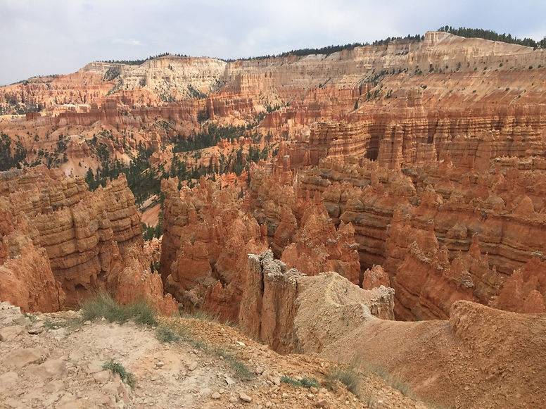
Figure 5 - Bryce Amphitheater. Note the criss-crossing pattern of weathering and erosion, the multiple Hoodoos, and the layers of differing oxidation resulting in "layers" of colors
_JPG.jpg)
Figure 6 - Bryce Amphitheater. Photo taken directly to the right of Figure 5.
_JPG.jpg)
Figure 7 - Bryce Amphitheater. Phot taken directly to the right of Figure 6.
_JPG.jpg)
Figure 8 - Views of the Bryce Amphitheater change continuously with angle of the sun and degrees of cloud cover.
_JPG.jpg)
Figure 9 - Roadway winding through Bryce Canyon. Distinctive Hoodoos permeate the lower half of the photo.
_JPG.jpg)
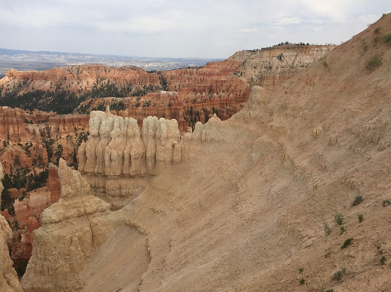
Figure 10 - White rocks are thought to be completely leached of iron oxide.
_JPG.jpg)
Figure 11 - Bryce Canyon is being cut into the Paunsaugunt Plateau in the background. In the foreground are talus slopes resulting from mass wasting of the pinnacles,
%20(Large)_JPG.jpg)
Figure 12 - Bryce Canyon is being weathered into the wall of the Paunsaugunt Plateau.
%20(Large)_JPG.jpg)
Figure 13 - Natural Bridge. 12.5 miles from main entrance. Differential erosion of softer sediments below cap rock has resulted arch formation within a "fin."
%20(Large)_JPG.jpg)
Figure 14 - A distinctive Hoodoo in Agua Canyon.