
SUNSET CRATER N.M.
FIELD TRIP STOP – CINDER CONE VOLCANO WITH ASSOCIATED AA LAVA FLOWS (HOLOCENE)
LOCATION: Sunset Volcano National Volcanic Monument is located about 16 miles north of Flagstaff, AZ off of US 89.
GEOLOGIC FEATURES: Cinder Cone Volcano; Fissure eruptions of mainly Aa lava.
DESCRIPTION: Sunset Crater Volcano is a 1000 ft. tall cinder cone volcano that erupted around 1085 AD. The volcano initially developed at the NW end of a 6-7 mile SE to NW fissure that exhibited lava fountaining. Spatter cones are found scattered along the ancient fissure towards the southeast. As Sunset Volcano developed, localized ejection of interlocking cinders was responsible for the steep slopes of the cone. In addition to cinders, the volcano ejected some lava blocks and bombs. Some flows of Aa lava flowed from the base of the volcano. The Bonito Flow, dated about 1180 AD and the most prominent flow in the area, extends about 1.6 mi. to the northwest of Sunset Volcano. It is mainly composed of Aa lava with some pahoehoe flows. Also found are lava tubes (some collapsed), squeeze-ups, and spatter cones. All in all, Tephra from the Sunset eruption fell over 890 sq. mi. with a maximum thickness of 40 ft. Three major lava flows from the eruption cover about 3 sq. mi.
On a broader scale, Sunset Volcano is part of the San Francisco Volcanic Field which has over 600 volcanoes within the southern part of the Colorado Plateau. Sunset Crater is the youngest volcano on the Colorado Plateau. Volcanism in the San Francisco Volcanic Field began about 6 mya in the western part of the field and then migrated eastward, forming 600 volcanoes along the way.
STUDENT QUESTIONS:
(1) What is Aa Lava?
(2) Define Cinder.
(3) What conditions account for the formation of a Cinder Cone Volcano versus the formation of more fluid lavas of Shield Volcanoes?
(4) Define Tephra.
(5) CHALLENGE: How does a Lava Dome such as found at O'Leary Peak and Darton Dome differ in composition and method of formation from Sunset Crater Volcano?
(6) CHALLENGE: Provide a reasonable explanation for the increasingly younger ages for volcanoes of the San Francisco Volcanic Field as you move eastward.
SELECTED REFERENCES:
-American Southwest. Sunset Crater Volcano National Monument. Accessed on 2/26/20:
https://www.americansouthwest.net/arizona/sunset_crater_volcano/national_monument.html
-Hanson, Sarah. (2009). Sunset Crater Volcano. Arizona Geology Magazine. Arizona Geological Survey. Accessed 2/26/20: http://azgeology.azgs.arizona.edu/archived_issues/azgs.az.gov/arizona_geology/april09/article_sunsetcratervolcano.html
-National Parks Foundation. A Volcanic Wonder – Sunset Crater Volcano National Monument. Accessed on 2/26/20:
https://www.nationalparks.org/explore-parks/sunset-crater-volcano-national-monument
-National Park Service. Sunset Crater Volcano (Updated 4/26/17). Accessed on 2/26/20:
https://nps.gov/sucr/learn/nature/geology.htm
-USGS: Volcanic Hazards Program. Volcanic History of Sunset Crater (Modified 12/19/18). Accessed 2/26/20:
https://volcanoes.usgs.gov/volcanoes/san_francisco_field/geo_hist_sunset_crater.html
PHOTOS: Photos are geographically arranged from the western entrance of the monument teastward to the Cinder Hills Overlook along the park road.

Figure 1 - Map of Sunset Crater National Volcanic Monument. Pictures below illustrate the Bonito Lava Flow, Sunset Volcano, and a view to the south from Cinder Hills Overlook.
Enhan30.jpg)
Figure 2 - Aa rocks of the Bonito Lava Flow are seen in the foreground. In the distance to the left is O'Leary Peak. To the right of that is Barton Dome. Both of these latter volcanic features are Lava Domes. View is to the north.
Enhan30.jpg)
Figure 3 - Rubble of Aa lava found in the Bonito flow. View is to the north,
Enhan30.jpg)
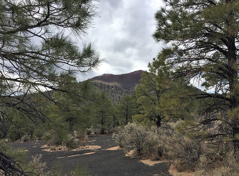
Figure 4 - View to the south of Sunset Crater Volcano
Enhan30.jpg)
Figure 5 - View up the northern flank of Sunset Volcano.
Enhan30.jpg)
Figure 6 - View of Sunset Crater Volcano from Cinder Hills Overlook.
Enhan30.jpg)
Figure 7 - Looking south from Cinder Hills Overlook of Spatter Cone volcanic features that erupted from the northwest trending fissure that leads to Sunset Volcano.
Enhan30.jpg)
Figure 8 - View from Cinder Hill Overlook of former volcanic activity along the NW-SE fissure that initialized volcanic activity in the area.